'It is better to light a candle than curse the darkness' Proverb
Showing posts with label Hiking. Show all posts

Sunday, 11 February 2024

Walking: Brynmawr to Crickhowell

I've been wanting to do some walks that basically involved me walking straight from my front door.  I was having a look at my OS Map, OL13, and saw that I could basically walk from here straight to Crickhowell.  Then I could just get the bus back home.  Unfortunately, I was too busy to do it on the day I had originally planned, so instead I did the walk a week later together with my husband.  I'm not going to lie, this walk wasn't my finest hour when it came to navigating as I didn't really bother concentrating on keeping to the route I had originally planned.  I wasn't hugely bothered as it was a pretty clear day and we were just out to enjoy ourselves, but it's not something I should really make a habit of doing as it could lead me into a dangerous situation.  In the future, I'll concentrate on practicing navigating and actually bother to use my compass as well.  It's not something I want to go rusty.

We started by walking up onto the road that leads to a footbridge at Braemar that crosses the Heads of the Valley road and then east along the new road alignment (not on our version of the OS Map) until we came to the stile that led us onto farmland and back onto the original route.  This bit was a nice gentle start to the walk and got us onto the commons pretty quickly.  The path on this side of the commons is small but still quite obvious - although I did still manage to take us slightly off track which led to me getting my feet very wet.  

Even though the route was supposed to lead us just below the peak of Twr Pen-cyrn, we decided we actually wanted to have a look at the Hen Dy-aderyn cairn at the top and so headed up that way instead.  After having a little nosey around, we headed down the other side and carried on towards the disused Llangattock quarries.  It wasn't immediately obvious which of the paths was the right one and, as I was being lazy on the navigation front, we did take a little detour before getting to the base of the quarry.  However, it was a clear day and the detour did mean we got a really good view of the valley below as well as the Black Mountains and Central Beacons.  We were also enjoying the fact that we were the only people up there - just us, a pretty strong wind, and some horses. 

The path that we were meant to take after the quarry turned out to be difficult to find (although we were able to find the other side) and I'm not into walking right past people's homes if I can help it, so we followed a vehicle track down which connected to the original path that took us along just below the escarpment.  We then followed the path that headed straight down to the bottom of the valley.  This bit was very steep, which would be fine if it wasn't for the fact that it was also quite slippery due to all the mud.  I slipped over a couple of times.  In fact, I was so busy concentrating on not slipping over that I completely forgot to take any photos of that section.  

The last section was pretty much just a road and then pavements through Llangattock and over the river to Crickhowell.  It was a little boring and it's never pleasant on your feet and legs to end your walk on pavements, but it did lead us to a lovely pint.  A very British way of ending a walk.

Despite the detours, this was an enjoyable walk with some pretty amazing views.  The slightly bleak weather made them all the more beautiful and I actually prefer that to sunny, clear days.  We're thinking of going back to the top of Twr Pen-cyrn, via the proper route this time, to have more of an exploration and really get to see what's up there.  We're also going to take a proper look at the Llangattock quarry which is apparently an actual tourist attraction.  However, next time I'll make sure I actually use my compass to properly navigate around.

Sunday, 21 January 2024

Walking: Aircraft Crash Hunting (or planning to but not actually making it in our case)

This is a walk that I actually did with others, my husband Ed and a friend of ours, but to say that it didn't exactly go to plan would be a complete understatement.  The plan was to do a route I had found on my OS map app which was supposed to take us by a WWII plane crash site and then pass a lovely waterfall that I thought would probably look quite pretty at this time of year.  However, this is what actually happened.

We started off from the car very near a pub just outside Glyntawe, which would hopefully have meant that we ended at a pub as well.  Then it was up towards the Black Mountain (though that wasn't our final destination), past a farm, and onto the mountainside.  So far so good, but then I managed to take us on a wrong turn which meant we were heading uphill a lot sooner than we should have been. However, it did mean that we missed a river crossing that looked a little tricky when we looked at it later on and a really steep walk up which we later walked down at the end.  Whilst a bit of a mistake we decided to just carry on up, joining onto the Beacons Way path that is on the route and doing the walk backwards instead.

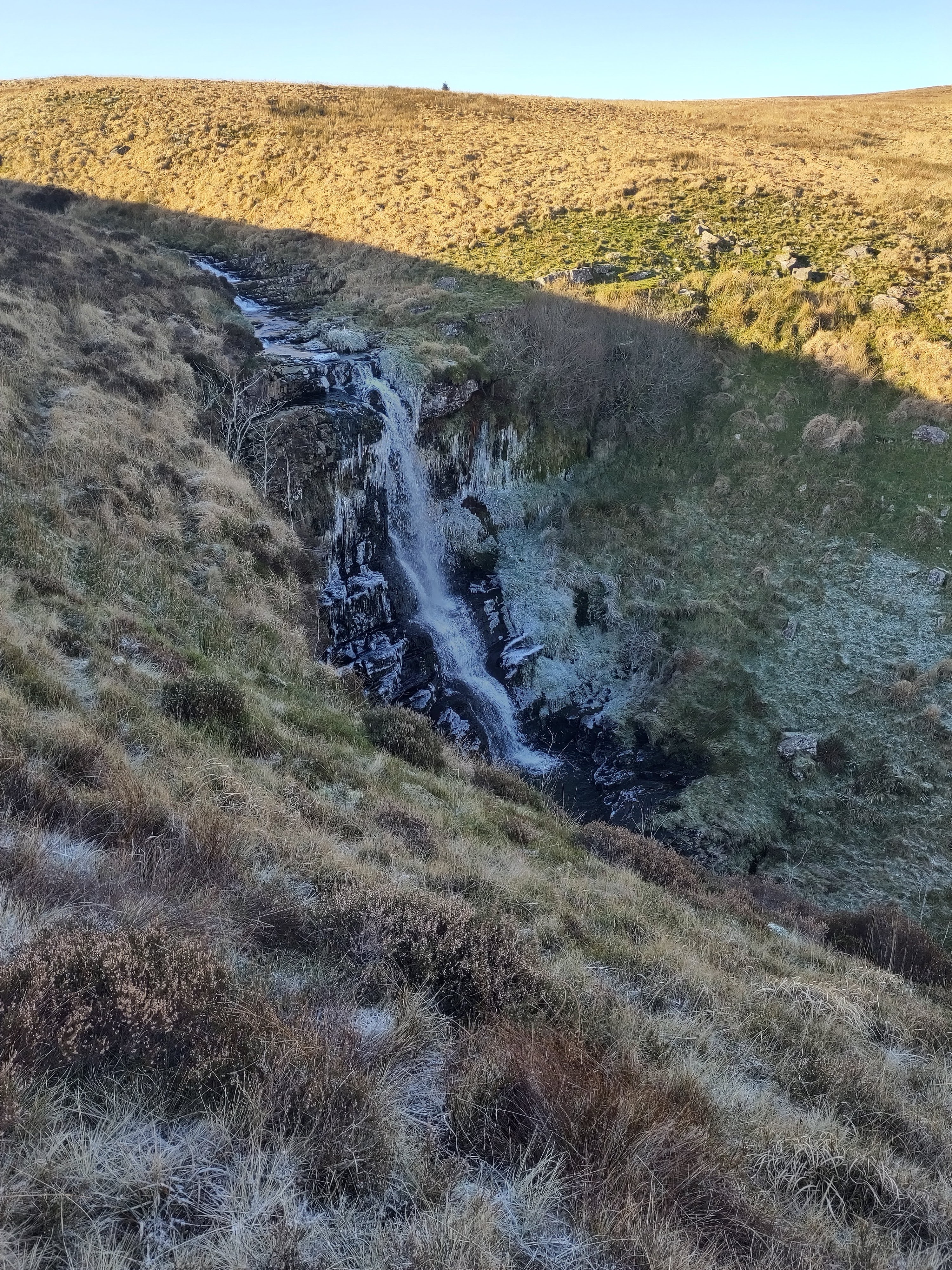
Once we had gotten back onto the path we did have a really good view north, where the clouds were rolling over the hilltop, and to the east where you could see some signs of old settlements on the other side of the valley.  A little reminder of how different things used to be.  We then followed the route off the main path and southwest towards the waterfall, stopping off at the remains of a shepherd's hut to have our lunch sheltered from the wind.  The waterfall was definitely worth stopping to have a look at, especially with the icicles that had gathered around it, and we spent a good few minutes just staring at it despite it being a little bit chilly out of the sun.  

The guys didn't want to take the route recommended on the app to cross the water as there was a lot of vegetation in the way, it was very boggy, and they weren't wearing wellies like I was.  So, we found another route that took us above the waterfall to find a crossing there.  Then we carried on southwest, weaving our way around all the shake holes there until we hit an actual footpath again.

Once we were on that we had a look at the time and the amount of daylight we had left to explore and decided we didn't really have time to safely go looking for the crash sites.  There wouldn't really have been enough light to see it properly anyway.  So instead we headed off to a rocky outcrop to have another look at the landscape from there before heading back to the footpath and down the hill past the largest crab apple tree I've ever seen to the car.  

So, not exactly as I had planned, but still a good walk.  And if I'm being entirely honest, if I was to pick which one I would rather see it would have been the waterfall, so I'm glad that we ended up doing the walk backward.  Will definitely be back to try and actually find this crash site next time around, though it'll probably just be a direct up and down that time.  One thing I did learn on this walk was that though it is nice walking with other people, I definitely prefer walking on my own.  It's much more relaxing, there's less pressure, and I get to walk at my own pace.

Sunday, 10 December 2023

Walking: Pont ar Daf to Dyffryn Cellwen

It had been quite a long week and I really felt like I needed to stretch my legs and give my mind a chance to just wander aimlessly, preferably in a location where there weren't other people.  So I decided to go on a long walk in the mountains.  For ease, I wanted to start somewhere where Ed could drop me off on his way to work, but I also wanted some parts of it to be in an area I hadn't been to before with some off-path sections so I planned on heading up Fan Fawr and then just going west.

I knew the weather wasn't going to be good and a little bit chilly, but it was meant to clear up a little as the day went by (though that didn't really happen).  I made sure I wore a number of layers and had more in my bag, along with a thermos of hot tea to make sure I was able to stay at the right temperature throughout the day and in case anything bad happened so I could protect myself from the elements.  I also took both my walking poles to give myself a bit more stability when crossing any rivers and when going through the boggier areas.  As an additional safety assurance, and because my route wasn't 100% fixed, I set my WhatsApp so that my husband could see where I was at any time.

So, from Pont ar Daf I headed to Storey Arms and up onto Fan Fawr, straight into the clouds.  It wasn't actually as cold as I was expecting, but it was as wet as predicted and I knew that my feet weren't going to stay dry for very long (I had also packed my trainers, some dry socks, and a miniature towel for when I finished - a luxury for sure, but definitely a good one).  However, I find as long as I can keep my body warm my feet do just fine in these conditions.

From the top of Fan Fawr I headed towards the trig point and then north with the plan of cutting across west a little bit later to look at some old, unused sheepfolds on Nant (brook) y Gaseg.  Unfortunately, at that point I couldn't see far enough in the front to be able to navigate properly so I decided to follow a path I already knew which would lead me to Nant Mawr, a tributary I could follow down to Nant y Gaseg.  From there it would be easy enough to find the sheepfolds.  As I was following this I finally came out of the clouds and could see them ahead of me and this allowed me to then take a more direct route.  

After a little nosey around it was time to cross over the brook.  It took a little while to find a safe spot as the water had risen quite a bit in the rain and the main issue was not trying to not get my feet wet (this had already happened) but more that you could see the rocks were a little bit too slippery to use safely.  However, I did finally find somewhere and I was very glad I had my walking poles with me.  Then it was straight up the very steep east side of Fan Llia back into the clouds.  If I'm honest, I actually quite enjoy walking in cloud cover and mist.  You may not get the views, but there's something very magical about it and I love how easy it is to mis-interrupt things you see in the distance and the changed noises that reach you.  

The plan was to then find a route down the west side of Fan Llia, cross the road, and look for a route around the side of Fan Nedd that would take me to the actual path leading to the top.  However, visibility had gotten even worse by this point and I knew this wasn't going to be a safe option at all.  So I changed my plans and decided to just follow the Beacons Way off Fan Llia and onto the Roman road I was planning on following later, leaving Fan Nedd for another day.  I have walked this path before so I took the slightly lower route this time, not that I could really see anything to make this really feel any different.  It was, of course, raining pretty heavily once I'd reached the bottom and it was time to have my lunch.  Nothing that a good, hot cup of tea couldn't fix though.

Then it was onto the Roman road for 2.5 hours.  I'd already walked just under half of this before when I had walked this section of the Beacons Way, and I have to grudgingly admit the other half wasn't any more fascinating than the first.  Up until this point, I hadn't bothered listening to anything on my headphones as I was enjoying the more natural noises of brooks, rain, and wind.  This time of year also meant that there weren't even livestock noises out on the hills, but now I needed a little bit of extra distraction so I put on some podcasts I'd been saving.  It was also quite a straightforward walk from here on so I could afford to concentrate less on where I was going.

As expected, it did get a little bit more complicated when I was walking through farmland and I ended up not being able to finish the very last part how or where I wanted.  Instead, I ended up walking along a B road which allowed me to look into the fields where the Roman fort and camp were meant to be.  It turns out there wasn't actually too much to see so I didn't feel like I'd missed out too much.  Then it was onto Dyffryn Cellwen to meet up with a friend who kindly drove me to get a pint or three.  Though things didn't exactly go to plan this walk was still exactly what I needed and, though physically tired, I felt much better afterward.  I also ended up with a lot more energy again, managing to get quite a lot done in the days following that walk.  It's definitely something I need to remember to fit into my days a lot more often.

Sunday, 20 August 2023

Being a Tourist 2023

Now that we are properly settled in here in Wales it's a good time to really start exploring what there is for us to see and do.  We've always felt that we didn't really explore Devon properly when we had the chance and we really don't want to make the same mistakes whilst we're here.  Especially as there is so much for us to see and explore around here.  Obviously, we are still trying to keep our spending low to help with our long-term goals, but we don't want this to be at the complete expense of enjoying ourselves now.  Thankfully, most of what we like doing is free /cheap and we have also been given a Cadw membership as a gift which has opened up even more things we can explore for free.

After doing a little bit of looking around we now have an initial list of places we want to see, walk, and swim around that are close to us, along with a couple of helpful books that will be useful as we're still getting to know the area.  This should make it easier for us to quickly make a decision about what we're going to do when we have time off.  Once we have more of a clue we can start working out our own walks to explore even more of the areas we've gotten to know.   One thing I definitely want to make sure that I do is explore the walks that are right outside our doorstep as it's all too easy to only think about walking in the Beacons, but then I'd be missing out.

As we've just started out we haven't crossed off too many things yet.  There is also the slight issue of our mismatching work shifts which means that we don't get as many days off together as we would like.  Though we would like to visit as many of these places together as we can, there have been some walks that we've done on our own just so we can still get out and see things.  We also want to fit these around learning to surf, but this just means that we have to be a little bit more organised to fit all these in.

Most of the places we've been about to cross off on our 'tourist board' I've already written about, but the most recent one was the Blaenavon Ironworks.  This turned out to be a very enjoyable day and also involved us having a little exploration around Blaenavon itself.  It's actually very close to where we live so I'm not entirely sure why we haven't visited it already.  It's very interesting to see how we use to make iron, but I personally really liked the workers' cottages that were on site and which they had decorated in the different styles of the decades that the cottages were lived in.  They seemed the perfect size for what we would like now, but maybe with a bathroom added on rather than just an outhouse down a lane.  There are a couple more industrial sites we would like to explore near us, especially as these played such an important role to those who lived here in southern Wales.

One thing we want to concentrate a little more on is wild swimming as we haven't done too much of that yet.  The warmer weather that is meant to be coming our way would make this the perfect time to really give this a go.  At least now we have all the equipment that we need to do this comfortably and we can just head out to a spot and enjoy it.  In fact, it would probably fit perfectly with surfing practice.

Sunday, 13 August 2023

Walking: Carmarthen Fans and glacial cwms (the Black Mountain area)

I finally got to go on a nice long walk with Ed again, which we haven't really been able to do since moving to Wales.  We've been wanting to walk in the Black Mountain area for a while as we had heard that the views were pretty amazing and it's a less popular area than the central Beacons, meaning that we were much more likely to be able to enjoy a walk without too many other people.  The weather wasn't meant to be particularly great on the day we had planned to do this walk, but we'd worked out this walk would probably take us around 4.5 hours and that's an acceptable amount of time for us to be out in bad weather.

The inspiration for this walk came from the Cicerone book 'Walking in The Brecon Beacons' and we mostly followed the route recommended in it, apart from at the end when we decided to take a more direct route to the car park away from the work happening at Llyn y Fan Fach.  We started at the Llyn y Fan Fach car park and, as the stream was too high for us to cross at the recommended point, headed back along the road to connect with the more southern Beacons Way that leads up to the Bannau Sir Gaer ridge.

There were some steep bits as you head up, but for the most part, this was a very manageable section for us and we didn't feel the need to take a break at any point.  We knew the weather would mean we wouldn't always get a great view, but when we did first get to the ridge of Bannau Sir Gaer we could see down onto Llyn y Fan Fach.  This view was only marginally ruined by all the vans etc that needed to be there and the very dubious myth that's connected to it.

The cloud did come back down again after this and we ended up walking the rest of the ridge surrounded by white and getting quite wet.  However, the path was very obvious and we were pretty confident that we could safely navigate the rest of the ridge so we carried on.  We also quite like walking in these conditions as it's a completely different experience walking whilst being cocooned in the cloud.  You tend to come across a lot fewer people in these conditions as well. 

Despite the lack of views, we were still able to pick out navigational features like the cairn at Picws Du (which is probably a prehistoric funerary monument), and the trig point at Fan Brycheiniog which marked the highest point of this walk.  There are a few paths along this way that head down from the ridge back into the valley, but we stayed at the top until we reached Bwich Gledd and then headed down to Llyn y Fan Fawr.

We hadn't been able to see this lake from the top, but it was a very pretty site once we were there and it also looked like a very good body of water to swim in.  Something we've taken note of for a later trip.  The clouds did of course lift once we had gotten down and we got a much better view of this glacier valley from this point on.  We were both pretty wet by this point, but still nicely warm and just a little less worried about the puddles we were putting our feet into as we headed west following the northern Beacons Way back towards Llyn y Fan Fach.

It was just before reaching Llyn y Fan Fach that we stopped following the route recommended by the book after we had noticed the path that cut off and headed more directly towards the Llyn y Fan Trout and Salmon Hatchery.  Unfortunately, it's the wrong time of year to watch the trout jumping, but it was still a surprisingly pretty spot to look around nonetheless.  

When we had been at the top we had decided that it had been far too windy and wet to stop for a lunch break, and as neither of us was feeling particularly hungry we decided to just keep going until we felt like we needed to eat.  This actually ended up being when we had gotten back to the car and had changed into a set of nice dry clothes that we always keep in the back of our car.  I actually find it surprisingly easy to walk long distances without eating and I don't think I'm alone in that.  There must just be something about walking that shuts everything else off, but you definitely feel very hungry once you do finally stop.

This was a great walk and we enjoyed it despite the lack of views.  The weather didn't put us off, in fact, it meant we got to enjoy it with fewer people than probably would have been there had the weather been great.  It's definitely an area we'd like to explore more of as it feels a little different from the central Beacons where we spend most of our time.  Time to plan some more walks I think, but maybe looking at ones where we can come in from the east as that would be easier for us to get to.  We obviously have to walk straight up the Black Mountain as well at some point, but I feel like that would be a time when I wanted a good clear day.

Sunday, 23 July 2023

Walking: Beacons Way Stage 5 - Storey Arms to Glyntawe


I've already written about the section of the Cambrian Way that I did a little while ago which also starts at the Storey Arms and ends in Glyntawe, but takes quite a different route to get there.  In that post I wrote about how I wanted to try the Beacons Way next to see the difference and, a couple of weeks later, I did.


The Cambrian Way is definitely the more direct route, but with the terrain being a little more difficult and the route a little less obvious I was expecting them to actually take around the same time despite the additional miles on the Beacons Way.  As before I actually started my walk at Pont ar Daf car park and walked up to Storey Arms before heading up the side of Fan Fawr and following the route on my OS Map.  As before I won't go into a description of the route as this is easily available online and is marked really well on the OS maps.  


As before, and with a number of my walks, I really lucked out on the weather meaning that, whilst I did need to repeatedly apply suncream, I did get really good views all day long.  This route was a lot easier to navigate through and most of the time it was pretty obvious which path I was meant to be on, even without too many sign posts, but there were still a couple of times where I needed to quickly check the app on my phone to ensure that I had actually taken the right turning.


The ease of the route meant that this walk was a lot kinder on the legs then the Cambrian Way, but the section on the Roman road was a little unpleasant on the feet and made being able to put them up during my lunch a must to ensure that the last section was actually enjoyable.  On the plus though, the Roman road does take you past another standing stone, Maen Madoc, which is believed to have been erected during the late Roman Period (though there is some thought that it may have been originally been erected in the Bronze Age) possibly as a burial stone given the Latin inscription on the side.


One of the best things about this walk was that, even though this is a relatively popular route, I was able to do it on a week day so that I mostly had it to myself.  In fact, I only really past three people giving me the time away that I needed and usually hope for when I'm walking in the mountains.


This time I decided to not go all the way the Glyntawe as I had already walked that section and cut off onto the path that runs south, parallel with the A4067, to end my walk at the Ancient Briton for a pint (always a good way to end a walk I feel) and to meet up with a friend.  This is a really nice walk and I would recommend it, especially to someone who is wanting to spend a day out in the mountains, but isn't 100% confident with their navigational abilities.  The wildlife on this route did seem to be a little less, but there's still a good amount of history to look at, spanning about 2000 years of Welsh history.  Even with low cloud cover you would still have plenty to see.  And now it's time for me to start organising my next walking trip.


Sunday, 25 June 2023

Walking: Cambrian Way Stage 7 - Storey Arms to Glyntawe


I was looking for some long walks that I could do to really stretch my legs and build up my mountain walking skills again.  One of the criteria I had was that it would need to start at a location my husband could drop me off at when going to his work.  Thankfully this wasn't a critical I needed to follow for the end poin as I'm very lucky in that he was happy to do a detour on his way home to collect me.  The two that fitted best were stage 7 of the Cambrian Way and stage 5 of the Beacons Way.  The Cambrian Way looked like it would require me to do a lot more navigational work so I decided to go for that first.


The directions for this walk can be found pretty easily online and in books so I won't go into that here, and I didn't quite follow it exactly as I started at the Pont ar Daf car park instead of Storey Arms and carried on walking a little longer once I'd reached Glyntawe so end up at Penycae further south.  So all in all I walked about 25km /15.5miles that day.


It did say in the directions for this walk that there were times where the route would either be faint or non-existent and there were a few times where I found myself just staring at my compass trying to work out what feature in the landscape I could use to navigate to.  For me though, this is the type of walking I really enjoy as it feels a little more like an adventure and you're a lot less likely to come across another person.  You also have to use your brain more and it was a good way to test my rusty navigational skills.  That being said, I was glad that it was a bright after a few days of dry weather as navigating some of these areas on a misty day when your feet are disappearing into wet, boggy vegetation wouldn't have been anywhere near as enjoyable.


There was a little bit of history to find on this walk, with a Roman Road to cross and a Bronze Age standing stone, Maen Elia, to look at.  Maen Elia was particularly striking against the surrouding landscape and a good reminder of just how long people have actually been using this mountainous area that we see as being wild.  There wasn't as much nature as I had hoped to come across which isn't too surprising as this is still quite a managed landscape, but I still got to listen to skylarks as I wandered a long and see a few red kites here and there.  One even flew right over the top of me.  Mostly I just enjoyed the quiet and the lack of people interaction I had despite me doing this walk on a Sunday.


I didn't find the end section of this walk quite as enjoyable as the start as you're just walking along an old tram line with not much change in the landscape to see.  Though it was still interesting to see just how far into the Beacons mining actually got and how the evidence of it isn't as obvious as you would think it would be seeing as it didn't end all that long ago  The village of Penwyllt was apparently once a thriving area due to mining, but you wouldn't think it when you walk past it now.  From here you walk through some actual fields, directly through the middle of someone's farm (which definitely felt a little weird), and a long some road before reaching the end point on the A4067.  It was here that I turned south and followed the footpath that runs parallel with the road to finish my walk with a pint in Penycae.  However, there is a much closer pub to the finish if you want to follow suit.


All in all I would say that this was a pretty good walk, though not necessarily one I would recommend if you don't have any navigational skills just yet.  It's obviously not a particularly popular walk and that means does you get to spend some time on your own.  There's are some interesting features in the landscape to look at and break up the walk a little.  The fact that I had beautiful weather on the day definitely helped, and that I didn't have a large backpack on my back.  This walk gave me a really good idea about the area and I enjoyed myself, though my feet maybe not so much.  Next - the Beacons Way, at least part of it.


Sunday, 11 September 2022

Walking: Horseshoe Ridge, Brecon Beacon


We decided that during our week off in August we would do some walking in Wales, specifically the Brecon Beacons which are the closest mountains to us.  After having a look at what walks there are we thought that the most interesting one would be the Horseshoe Ridge as it's right in the centre of the Brecon Beacons, is a good walk that is challenging but not really difficult, and it includes the two highest mountains in the Brecon Beacons (and south Britain).  


I was having a look at some of the recommended ways of doing this walk and decided that the best one was the one recommended by my Ordinance Survey app.  It also meant that I could check where we were on my app and my husband could carry the physical map and compass in case anything happened to one of us.  We started at the Taf Fehan car park (which is literally labelled on Google Maps as the Brecon Horseshoe Walk car park) and followed the path that takes you up the reservoir.  It did take a little while to get to this car park (and there's no public transport to it) and there aren't any facilities there, but it's definitely worth doing the walk from this starting point.  When you get to the reservoir you get a really good view of the glacier valley you're in and all the peaks you'll be heading to during this walk.


At the reservoir we followed the path left (which got a little bit confusing around the buildings but we found our way in the end) and then headed up the very steep climb to the Graig Fan Ddu ridge.  This definitely gets your heart going, but also means that you've done most of the climbing right at the start making the rest of the walk a bit easier.  I also wouldn't want to do this part near the end of my walk.  Once we'd reached the top we turned right and heading along the ridge to Corn Du.  This bit of the walk is really lovely, easy on the legs after the straight up climb, and you get a really good view of the valley with all the birds flying around the area.  There also wasn't too any people at this point, unlike the peaks we got to later.  


Corn Du is the second highest point in the area and has a Bronze Age burial cairn at the top of it.  There is a little scrabbling section just before you reach the top, but otherwise this is a pretty straight forward hike to the top.  Then you drop down into the saddle and straight up again to the top of Pen y Fan.  There were a lot of people at the top of this peak and, even though the views were pretty amazing and I usually enjoy pottering around the top of mountains when I reach them, I really didn't want to spend too much time there this time.  For me, going out into the wild is about being away from other humans so meeting lots of people there is never particularly enjoyable for me so I dragged my poor husband down the other side pretty quickly. 


It's a pretty steep climb down Craig Cwm Sere and an almost similarly steep climb up to the top of Cribyn.  The top of this peak was much quieter and we did stay a little bit longer before turning right and carrying along the path down the other side.  It was at this point that we past an 80 year old lady practically skipping past us up the mountain, making us feel very unfit.  This walk down is a double descent, where you descend half way down quite steeply and then get to walk for a little bit along a flat ridge, which I would imagine would be quite boggy normally but as it had been pretty dry over the summer was actually quite easy to walk on.  This is where we decided to stop and finally have our lunch as well as reapplying some suncream.  Then we dropped down again to the cross road with Gap Road.  This is labelled as a Roman road, but I couldn't find any archaeological evidence for this.  However, it was one of the first horse and cart roads over the Brecon Beacons.


As we wanted to hit the five points on this walk we crossed over the Gap Road and headed up the last climb to the top of Fan y Big.  You can get very close to the edge here and get a really good view back across to the peaks you've just climbed.  We then climbed back down the route we'd taken up to get onto Gap Road and headed back to the car park.  I was hoping this last section was going to be a gentle road back to help us cool down before we had to get into the car, but unfortunately this path ended up being a complete foot destroyer with loose stones all over the place.  It was almost nice to get back to the tarmac road which takes you to the car park.


On the day we had originally planned on doing this walk it was meant to rain with thunderstorm warnings for up on top of the mountains.  Even without the storm it was going to be very foggy, which isn't the safest way to climb a mountain or the best way of seeing the views.  So we decided to put it off until the next day where we got clear blue skies and views across the whole of the Brecon Beacons.  It wasn't the most difficult walk we've ever done, but it was still quite physical and gave us a pretty good leg work out.  Pen y Fan is obviously a very popular destination, to be expected on a good day and a peak that is close to good parking spot on a main road, but the rest of the walk wasn't too bad when it came to the number of people you come across.


We did really enjoy this walk and it was nice to get back out into some mountains again.  It would have been nice to have done some more walking when we were there, but we didn't want to push it too much seeing as we haven't done this type of walking in a while and we were already aware that our fitness levels aren't as high as they use to be.  I would definitely recommend this walk if you're in the Brecon Beacon area and I'm glad we came here to do it.  We want to come back to the Brecon Beacons again as it's beautiful and very close to us, so we'll be looking at what other walks we can do in this area for the next time we come.